Ya ol’ Maps
When I grew up, we still did everything with maps – reading maps was actually part of your education.
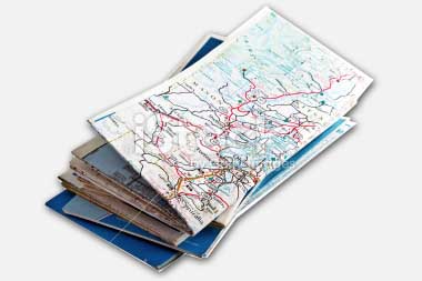
You might remember them: those ginormous paper things, squeezed in the glove compartment with a bunch of other maps that often seemed impossible to fold properly, often outdated, with your location barely falling of the map so that you’d have to buy a new one at the gas station in order to find your way.
If you don’t recall seeing them: ask your parents or grandparents … they can probably tell you some horror stories navigating with maps. Mom reading the map, dad yelling for directions while driving, with whining kids in the back, and getting stranded asking for directions in the end (if dad’s pride allowed it). 
As you can imagine, a desire for an electronic automated system was definitely there, specially for military purposes. Unfolding and carrying huge military maps sure made covert ops more of a challenge … the need for GPS was born.
Your classical car maps
Ad Blocking Detected Please consider disabling your ad blocker for our website.
We rely on these ads to be able to run our website.
You can of course support us in other ways (see Support Us on the left).
GPS … the beginning …
GPS or Global Positioning System was originally build for military purposes, no surprises there, with origins as early as the 1960’s.
In those days the US government funded the development of GPS systems mainly with the cold war and nuclear threat in mind, which since then has gone through a few iterations to improve coverage and accuracy. With the cold war in mind, GPS used to be covered in secrecy of course, but today these systems are (more) open to the public.
Obviously, we’re talking about the cold war days, so Russia (USSR at the time), China and Europe eventually developed their own variations as well, making it that GPS pretty much covers the entire globe, specially when you combine two or more of these systems.
There are currently 5 systems in orbit:
Most common “household” GPS systems or devices utilize Navstar, Galileo and GLONASS.
In this article we’ll focus on Navstar as it’s probably the most commonly used system, and because other systems work in a similar way.
Note that the GPS receiver requires compatible hard and software to support the system you’d like to use. The initial GPS devices had receiver chips that only supported Navstar, but more and more devices support more than one system. You’ll see Navstar and GLONASS more often combined in one receiver chip, and in the European market Galileo support can be found in combinations as well.
More and more devices, like your smartphone, tablet PC’s etc, are GPS capable. Not to be confused with location triangulation based on WiFi often used when GPS is not available (lacking hardware or location has limited GPS coverage, indoors for example). WiFi Positioning Systems do work in dense populated area’s where plenty WiFi hotspots can be found, but even then it’s not nearly as accurate as GPS. If I would have to make a guess, WiFi Positioning Systems can reach at best a 100 meter accuracy.
GPS is claimed to have a 7.8 meter accuracy with a 95% confidence level, which is pretty good (source), but it takes a little bit when you fire up your GPS device to pick up the needed satellite signals for your current location.
An alternative is the use of cell phone towers for location determination. Cell phone towers have a known fixed location and like with WiFi Positioning systems, the strength of the signal and the known locations are used to determine where you are. From experimentations I’ve seen in my Ericsson days, this method is actually pretty accurate, but I haven’t seen it to be more accurate than 20 meters. Still a reasonably good alternative.
Some manufacturers combine GPS with Cell-tower Positioning and/or WiFi Positioning as an add-on to speed up the determination of the start location. Other tricks include remembering your last location, manual entry of your current start location, or scanning for locations you’ve been before.
Picking up the satellites could be compared with you using a regular radio, trying to find the 4 strongest stations you can receiver. So let’s say you’re using an FM radio: you’d have to move the frequency dial slowly from 87 to 108 MHz and write down each station you find and it’s signal strength. Try imaging doing that … you’ll find that it takes a lot more time than expected.
To improve speed several tricks are being used. One of them (in the same analogy) would be that a person would give you a hint by saying that the strongest stations can be found between 92 Mhz and 98 Mhz – limiting your search to a much more narrow scope. For GPS we have similar tricks (See: GPS Lingo).
By now you’ve figured out that when people talk about “their GPS” that they really only mean their GPS receiver …
Navstar
At the time of me writing this article, Navstar counts 27 solar powered satellites in orbit. 24 of them in active use and 3 as a backup in case one of the 24 fails. The illustration below (source) is an abstract illustration of the Navstar satellites orbiting earth.

Navstar Satellites orbiting earth
Back in the day, and this might still be the case in some fashion, when GPS was opened for the public, accuracy for public use was limited. Obviously the military wanted to have the best accuracy for themselves and most certainly did not want to share this with potential enemies – and frankly I can’t blame them for that!
Each of these satellites weighs about 4,000 pounds (about 1,800 Kg) and circle the globe at an altitude of about 12,000 miles (19,300 Km). Just for comparison: you’re average commercial airline plane reaches an altitude of say 10 Km.
Ad Blocking Detected Please consider disabling your ad blocker for our website.
We rely on these ads to be able to run our website.
You can of course support us in other ways (see Support Us on the left).
How GPS works
Now that we know about the satellites orbiting earth and some of the history: how does GPS work? How is your location determined?
GPS uses a mathematical (geometry) method called Trilateration (sometimes wrongfully called Triangulation).
I’ll try to explain this in an easy way …
Say you’re traveling and you ask at a given location a person where you are and this person says: “you’re 100 miles form city A“.
Based on this information you can draw a circle around city A and you’ll know that you’re somewhere on this circle:

100 miles from city A
Obviously not very helpful, unless you know more details where you’re located in relation to City A.
Now we ask a second person and this person tells us: “you’re 75 miles from city B“.
Again we draw a circle, this time around city B and, and if everything is correct, we will notice that the circles around city A and B intersect at least at one point (if you’re lucky), but more commonly intersect at two points – the black dots in the picture below.
This means that our location, if all information is accurate, is one of these two black dots.
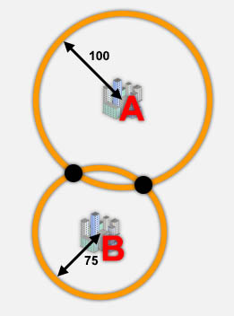
Our location with 2 reference points
The 3rd person we ask says “You’re 200 miles from City C“.
Again we draw a circle, which results in the following:
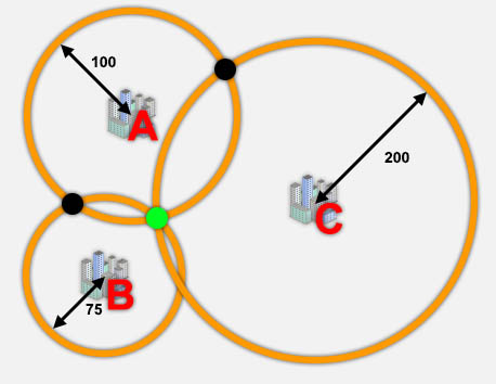
How GPS Works: 3 Reference points for our location tells us where we are
Again, the new circle intersects with the previous two and guess what … if your information would be 100% accurate, you’d end up with 1 point (the green dot) where all 3 circles intersect. We’ve found out location: the green dot.
This example only illustrates 2D Trilateration. Earth however not a flat pancake, in contrast to popular believe in the dark ages. It’s a 3D object and that’s why GPS systems use this method with spheres instead of flat circles. The spheres in this, allows us the determine altitude as well.
Also note that we were talking about a distance related to cities, with GPS however it’s distance related to a satellite and amongst satellites. To properly determine your location at least 3 satellites (4 is preferable) need to be in sight and your device needs to know it’s location related to those satellites.
Your GPS receiver does all that with the help of a low-power radio signal emitting from the visible satellites, and with some hi-tech math can determine your location on the globe expressed in latitude (horizontal or from left to right – see the left globe in illustration below), longitude (vertical or from top to bottom) and altitude (height). Combined with map data it can then tell you where you are.
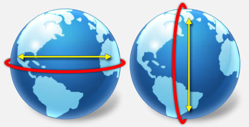
Latitude (left) versus Longitude (right)
More complex calculations
As mentioned before, some hi-tech calculations are done by your GPS receiver, and the reason for this (and the reason for not being 100% accurate) is that with these calculations quite a few hurdles need to be taken.
Measuring Distance
So how does your GPS receiver determine the distance to these satellites?
A GPS receiver measures the time it takes for the radio waves to travel from the satellite to your GPS-receiver. Since radio signals travels at the speed of light (in vacuum space!), about 299,792 km/s (app. 186,000 miles/s), we can figure out how far the signal has traveled by figuring out how long it took to be receiver by you GPS-receiver.
Compensation is needed though since … we don’t live in a vacuum … so correction is needed. But not just because we don’t live in a vacuum. Several atmospheric condition can slow down radio waves as well.
Measuring Time
To measure the time it takes for a radio wave to travel from satellite to GPS receiver we’d need a very accurate clock, like one of those Atomic clocks. But those guys are VERY expensive and in general do not fit in a portable device. So instead of installing horrendously expensive clocks in each satellite and each GPS receiver, another trick is used.
The satellite transmits a long digital pattern (a pseudo-random code) as part of its signal at a given time. Your GPS receiver begins generating the same digital pattern at the same time (according to it’s internal clock) as the satellite does albeit with a slight time difference.
When the satellite’s signal reaches the receiver, its transmission of the pattern will be a bit behind or ahead of the receiver’s pattern. If clocks would be in sync, then length of the delay is equal to the time of the signal to travel. The receiver multiplies this time by the speed of light to determine how far the signal traveled. If the signal traveled in a straight line, through a vacuum, then this calculated distance would be the distance to the satellite.
Accurate clocks are needed for this, because the time measured in these calculations must be accurate into nanoseconds – believe me: one second at the speed of light will result in a pretty stiff walk! One nanosecond when traveling at the speed of light is about 1 foot or about 30 cm. Keep in mind that 1 second = 1,000,000,000 nano seconds. So one second results in a 1,000,000,000 feet or almost 190,000 miles or almost 304,800 Km!
The Global Positioning System has cool trick to solve this problem.
First let’s start with the GPS receiver which uses a normal and cheap quartz clock similar to the clock in your computer or electronic watch.
The receiver looks at all the signals it is receiving and uses calculations to find both the exact time and the exact location simultaneously. However, due to the clock’s being out of sync, the spheres will not intersect at exactly the same point – the error will actually be proportionally incorrect. The error in these points matches the difference in time (OK it’s not easy to calculate this – but your GPS receiver is a little computer on itself, perfectly capable to handle this).
Now that your GPS receiver knows what the inaccuracy is, it can compensate for that and determine the correct point of intersection. Or in other words: your location. Interesting side effect, and I’m curious why this is not utilized more, is that your GPS device actually has a very accurate time indication!
Now that we know longitude, latitude and altitude, we can pinpoint our location on a map – and maps (as you might have noticed) get updated frequently.
Ad Blocking Detected Please consider disabling your ad blocker for our website.
We rely on these ads to be able to run our website.
You can of course support us in other ways (see Support Us on the left).
Some GPS lingo
Now that we have a basic understanding of how GPS works, we can proceed to some GPS lingo that you might run into when buying a GPS device.
Improved Accuracy
There are a few tricks to improve the accuracy of a GPS receiver. Yu’ll run into phrases like DGPS, WAAS, etc.
DGPS or Differential GPS seems (I could be wrong) the first attempt to improve accuracy by adding signals from ground stations. Or better said: a network of devices, at a fixed and know location, emitting radio signals that you GPS can pick up and incorporate in it’s calculations.
WAAS (USA), EGNOS (Europe) and MSAS (Asia) work in a similar fashion and I can recommend buying a GPS receiver that supports this for your region.
Claims have been made that accuracy can go up to 10 cm or almost 4 inches! I’m calling it “claims” for a reason, so don’t go buy such a DGPS or WAAS enabled GPS device and expect that kind of accuracy. Accuracy however will be better in general.
Communication
The first GPS devices that could be connected to computers used the good old serial port, not to be confused with USB, and used NMEA as a protocol to “talk” to each other. The NMEA protocol is not jus used for GPS devices, but it is the most commonly supported protocol by GPS applications.
So if you decide to connect your GPS to your computer: NMEA support is almost a must.
Keep in mind though that different GPS devices might speak different dialects, and might not always be as compatible as you’d hoped. So always check with the application manufacturer if it supports your particular GPS device. Searching the Internet is also recommended as you’re probably not the first one to connect your particular GPS device to your computer. There are a lot of user groups out there!
Chipset
This is where things become difficult … so far I have seen 4 major GPS chip manufacturers, all with their nicely confusing naming convention.
SiRF is probably the most well known chipset manufacturer and it appears that you’ll find their chips in the more expensive and higher quality devices. The codes they use can be daunting to most of use, but maybe the easiest way to select the one you’d like to see in your GPS device are the ones with the highest number. I know … it sounds simple. I found digging into the details to be confusing at best.
Current models (2013) are SiRFstarIII, IV and V. If you’re using your GPS internationally, then the SiRFstarV series is recommended.
Other brands are: MediaTek, SkyTraq and u-Blox. These brands are most certainly not bad and I’ve noticed that SkyTraq can be found in quite a few Chinese GPS receivers. Commonly though support for SiRF chipsets seems better specially when it comes to communication with computers (NMEA command set).
TTFF or Time To First Fix
TTFF indicates how fast a GPS determine it’s location – i.e. have a fix on your location. This strongly depends on the type of “start” but is often used to indicate how “good” the GPS receiver is. I’d prefer to think of it as how good the antenna, chipset, and software work together at start up. Having a good antenna for GPS signal however is a good indication of how “stable” your GPS signal wil be.
Cold Start vs Warm Start
These phrases are an indication how a GPS device starts and how long it will take for a GPS device to lock into it’s location.
With a cold start, all data in your GPS receiver (except the maps of course) are considered invalid. This means that your GPS has no reference and has to start from scratch, which takes more time.
A warm start on the other hand means that your GPS still has data available that is valid, for example some help from previous locations you’ve been, or because the GPS has been on standby or sleeping. This makes the search for satellites much faster as it will first go through the satellites it has seen last versus starting at satellite 1 and working your way up to number 24 (Navstar).
QuickFix, Instant Fix, or A-GPS
All 3 work on the same principle and sometimes it’s just the fancy name a manufacturer picks to distinguish themselves from the competition.
QuickFix or Instant Fix uses a data file that you can download from the Internet and remains valid for about a week. The data in the file you downloaded contains information your GPS usually would receive from a GPS satellite, but in this case downloaded data is used for the initial calculations which again speeds up getting a location fix. Unfortunately, it does require a manual download an install.
A-GPS on the other hand relies on cellular towers, so the information loaded into your GPS will last longer (in general cell-towers don’t move too much). The signal of cell-towers is used to identify quicker where you’re roughly at and what satellites to look at. Commonly A-GPS is found in cell enabled devices like cellphones and tablets PC’s that have data via cellphones.
Note that more and more devices, like smartphones, utilize the visibility of certain WiFi networks, in a similar way.
Common GPS devices
Back in the day, a GPS device was either very expensive and included an LCD display and such, or relatively affordable and had to be plugged into your computer or PDA (Personal Digital Assistant – you know those devices from the pre-smartphone era).
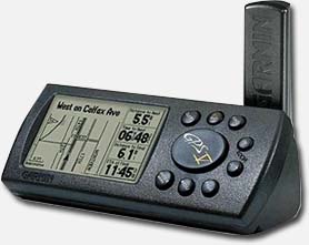
Older GPS Device
Overtime brands like Garmin started introducing affordable portable GPS devices with a nice display. Probably one of the best known series is the Garmin eTrex series. Not only portable but also connectable to computer or PDA.

Garmin eTrex
GPS systems were initially more for aviation, hiking and boating navigation. Car navigation took a while to surface, first in luxury cars or with the help of a PDA running an application like TomTom (still my favorite!) hooked to a GPS device.
Companies like TomTom didn’t sit still and soon dedicated car navigation devices could be bought for an acceptable price.
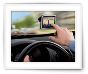
The arrival and increased popularity of smartphone with build in GPS receiver opened a whole new market of GPS users. Applications like TomTom and CoPilot (available on iPhone and Android platform) have become very affordable and the phone hardware has come a long way to accommodate these GPS applications.

iPhone running TomTom
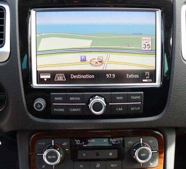
In the meanwhile GPS navigation systems are getting more and more common in cars. GPS navigation is being used on motorcycles and bicycles as well, and devices like the smaller handhelds from Garmin are more capable than ever.
GPS finds more applications than ever before … think about tracking your kids or your stollen car (LoJack).

Modern car navigation (VW Touareg 2011)


Comments
There are no comments yet.
You can post your own comments by using the form below, or reply to existing comments by using the "Reply" button.